I am doing a geospatial assessment integrated with ML modeling. The problem is the very low accuracy percentage, as more training features increases, it gets lower. What could be the solution to such a problem?
Accuracy test: 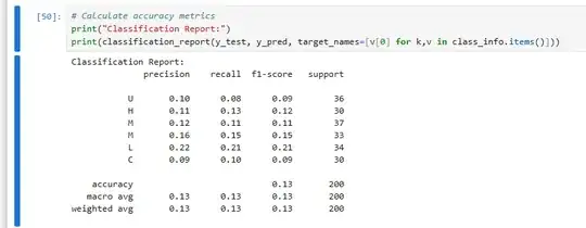
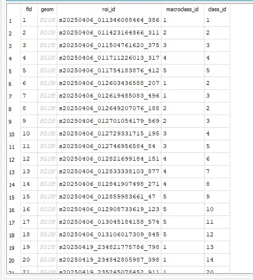
Sample of training data:
CODE:
ndti_path = r'\try2.tif'
train_path = r'trainGPKG.gpkg'
Read training data - through geopandas
train_gdf = gpd.read_file(train_path)
X = []  # Features (NDTI values)
y = []  # Labels (class IDs)
for idx, row in train_gdf.iterrows(): #iterates over each polygon
    geom = row.geometry
    class_id = row['macroclass_id']
# Convert polygon to pixel mask
mask = rasterio.features.geometry_mask(
    [geom],
    out_shape=ndti.shape,
    transform=transform,
    invert=True
)

# gget NDTI values inside the polygon
values = ndti[mask]
values = values[~np.isnan(values)]  # Remove NaN valuees

if len(values) > 0:
    ###  statistics for each polygon
    X.append([
        np.mean(values),
        np.std(values),
        np.median(values),
        np.min(values),
        np.max(values)
    ])
    y.append(class_id)

rf = RandomForestClassifier(
    n_estimators=100,
    random_state=42,
    class_weight='balanced'
)
rf.fit(X, y)
classified = np.zeros(ndti.shape, dtype=np.uint8)
rows, cols = ndti.shape
for i in range(1, rows-1):
    for j in range(1, cols-1):
        window = ndti[i-1:i+2, j-1:j+2]
        values = window.flatten() #Clean Data, convorts into 1D array and remove NaN values
        values = values[~np.isnan(values)]
    if len(values) > 0:
        features = [   ##Compute features if valid pixels exist
            np.mean(values),
            np.std(values),
            np.percentile(values, 25),
            np.percentile(values, 75),
            len(values)
        ]
        classified[i,j] = rf.predict([features])[0]